
The McCarthy Road
Beginning at the Copper River and ending at the Kennicott River, the McCarthy Road spans approximately 58 miles. For the most part, it follows the roadbed of the Copper River and Northwestern Railway which was constructed between 1908 and 1911. For 27 years the 196 mile railway carried copper from the historic Kennicott mining area to the coast at Cordova. The last train pulled into Cordova on November 11, 1938. What is now called the McCarthy Road is a portion of that momentous construction project!
The rails and ties were eventually removed for salvage. Culverts were set in place and the road graded in the 1960's. Even though the road has been slowly upgraded since then, it is still a dirt road, narrow in places, and requires caution especially around curves. Be sure to include a reliable spare tire for your vehicle. The facilities along the road are minimal, and old railroad spikes are known to surface on occasion.
The McCarthy Road is surrounded by the 12 million acre Wrangell-St. Elias National Park and Preserve, but the road and most of the nearby lands are not part of the Park. Much of the lands are privately owned. Following along the base of the Wrangell Mountains, the road makes a gradual climb from an elevation of 500 ft. at Chitina to 1500 ft. at McCarthy.
View The McCarthy Road in a larger map
If you would like to try your hand at fishing, why not stop at the following lakes:
- At Mile 10, a foot trail leads .3 miles (through private property) north to Strelna Lake and Silver Salmon, Kokanee and Rainbow Trout.
- Mile 11 The Silver Lake Campground, has trophy Rainbow Trout fishing, boat and canoe rentals, RV and tent camping as well as tire repair.
- Sculpin Lake Mile 12 has Rainbow Trout, Silver Salmon, and Kokanee.
One of the major attractions - or "distractions" to some - is the Kuskulana River bridge at Mile 16.
Built in 1911 it spans a 283 ft. gorge on the Kuskulana River. The approximately 600 ft. steel bridge
received new decking and metal guard rails in 1988.
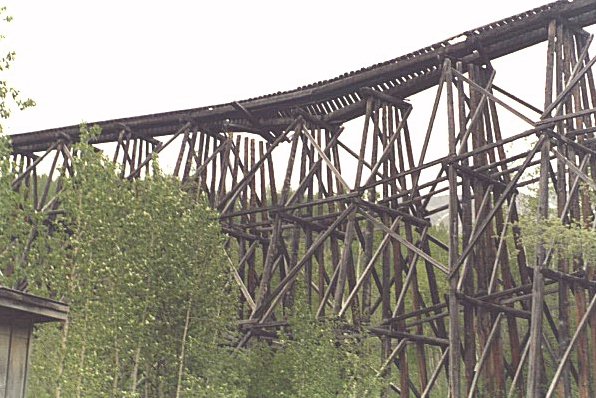 Another major historic attraction is found at Mile 28. To the north of the road, you will see
what is left of a railroad trestle. Near the base of the old trestle, is a small, modern bridge built in 1990
that spans the Gilahina River.
Another major historic attraction is found at Mile 28. To the north of the road, you will see
what is left of a railroad trestle. Near the base of the old trestle, is a small, modern bridge built in 1990
that spans the Gilahina River.
Be sure to stop at Mile 55.5 and check out all of the Alaskan crafts at the Willow Herb Depot.
Mile 58.5 - McCarthy Trail Rides B&B offers accommodations plus custom tours and local information. Road to the right leads 1.8 miles to the Wrangell St. Elias News B&B.
Mile 58.7 - trail on left leads to the Kennicott River Lodge and Hostel.
Mile 59 - the end of the road. Copper Oar offers river rafting trips. You cannot drive into the town of McCarthy the road ends at the Kennicott River where a newly constructed (spring of 1997) foot bridge allows pedestrian access into town.
Whether you choose to fly or drive, our desire is for your visit to be a pleasant one. We hope you will discover a part of history that should never be forgotten!
Don't feel like driving yourself? Use one of these services:
Backcountry Connection
(866) 582-5292
www.kennicottshuttle.com
Wrangell-St. Elias Tours
(907) 822-5978
www.alaskayukontravel.com
Credit where credit is due
Articles above are from A Visitor's Guide to Kennicott & McCarthy, and are reprinted, in part, with permission of Kenyon Services.
A Visitor's Guide to Kennicott & McCarthy is published by Kenyon Services, McCarthy, PO Box MXY, Glennallen, Alaska 99588. Phone (907) 554-4454 or Email [email protected]. Copyright 1996. all rights reserved. The Guide is distributed free to area visitors. Single copy mail requests enclose $1.50 for postage. Publishers & Editors Rick & Bonnie Kenyon. Thanks to Ed LaChapelle for articles on Glaciers, Creeks & Rivers, How to be a Welcome Visitor, and How to use the trams.
Photographs: Agnes M. Hansen, Valdez, Alaska
Hotels/Motels & Roadhouses
Great places to Eat
Campgrounds & RV Parks
